- General
- Selection
- Competitions
- Drug testing
Schedule/Results
- Track
- MTB
- Road
Course Maps
- Velodrome
- MTB Course
- Road Course
Event Previews
- Track
- MTB
- Road
- Time Trial
Team List
- Track
- MTB
- Road
Diaries
-
Marion Clignet
-Anna Wilson
-Karen Kurreck
Course Maps
Road Course Track Description Mountain Bike Course
•Road Cycling Course • Centennial Park/Eastern Suburbs
 |
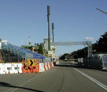 |
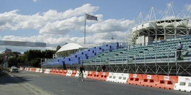
| A lone cyclist heads back down the course over the finish line outside the Sydney Football Stadium. | The finshing touches are being added to the spectator area at the start/finish line. |
Course Description:
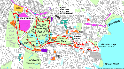
The Olympic road course is a circuit of 17 km, taking in some spectacular scenery around Sydney's Eastern Suburbs such as Bronte Beach before heading back through the city's green belt of Centennial Park and finishing outside one of Australia's sporting monuments, the Sydney Cricket Ground. At one stage, the race was going to be held on a boring, flat course at Bankstown, in Western Sydney, which would have been a disaster for spectators and athletes alike. However, sanity prevailed and the course was moved back to its present location.
The reinstatement to the original was coupled with a reversal of the route to an anticlockwise direction in September 1999, after an inspection by UCI president Hein Verbruggen, and 1996 Tour de France winner, Bjarne Riis. The reason given was that following cars may come to grief on the descent into Bronte beach. However, there is now a sharp left hand bend on the counterclockwise descent into the beach which is potentially dangerous. Due to the road closure, the riders will not at least have to deal with cars coming up the other way. Similarly, the short but steep ascent up Queens Park road will now be a fast and again tricky descent in the new route.
The race starts outside the Sydney Cricket Ground gates in Driver avenue, and the riders have approximately 5 km of flat, open, and fast roads as they turn left into Moore Park Rd, Anzac Parade, Alison Rd, and Darley Rd, skirting around Centennial Park. This will be a key part of the course for those wanting to gain position before the more technical climbs and descents begin. This will be dependent on the wind, however.
The first incline is encountered up Darley Rd up to McPherson St (800 m at 5%), which will not hurt at first but will be a drag later on, especially as it is relatively exposed to the left. The short 700m descent into Bronte beach follows, with the riders negotiating the sharp left hand bend mentioned earlier. The bottom part is quite steep, and speeds of around 90 km/h should be reached. This is certainly one of the more spectacular parts of the course for viewing, although there won't be much in the way of attacking going on.
The hardest of the climbs follows immediately after (1.2 km at 6.6%) - it is split into three sections, with a flat spot in the middle for 150m. Although the momentum of the bunch will make it fairly straightforward early on in the race, it will start to hurt by the halfway point. The road is narrower here and the position gained before the descent will be crucial for those wishing to make the selection later (or earlier) on in the race.
At top, the route follows Bronte Rd for 300m before turning left into Victoria St and then Queens Park Rd. A 300m fast, sweeping descent follows, again allowing for some spectacular viewing, before levelling out and turning left into Baronga Avenue. Left again into York Rd for 500m, and then a sharpish right into Centennial Park via the gates at Musgrave avenue. The riders will then turn right into Grand Drive (normally one-way the other way) and ascend for 1.2 km at 3.3% on the final climb of the circuit.
Although not particularly steep or exposed, the top part of the climb up Robinson Drive and Loch Avenue could see the winning move late in the race. A sharp left at the top, followed by 800m of flat (Carrington Drive), then a left again down Parkes Drive. Not an overly steep descent, but it is 1.2 km of straight downhill which may make it tough for a lone escapee to hold off a charging bunch. Then it is right into Grand Drive again for 1.2 km of gradual downhill/uphill, then left at the top along Lang Rd for 500m before the final right hander into the finishing straight. The finishing drag is slightly uphill for approximately 500m from the corner and could well be a tailwind, if Sydney maintains its usual September weather patterns - definitely not a given.
The key selection point will probably be the narrowish climb up Bronte road, as position as much as strength is important here. Riders caught behind any crashes down into Bronte will find it very hard to recover up the other side. However, the winning move may come as mentioned above on the last incline in Centennial Park, with approximately 4 km to go. If the wind is favourable down the hill afterward, a lone rider may stay clear, or more likely a group of three. The final sprint will have to be timed perfectly, as those who want to win will have to resist the temptation to go from the corner, unless there is a tailwind. The finish outside the Sydney Football Stadium will be great viewing.
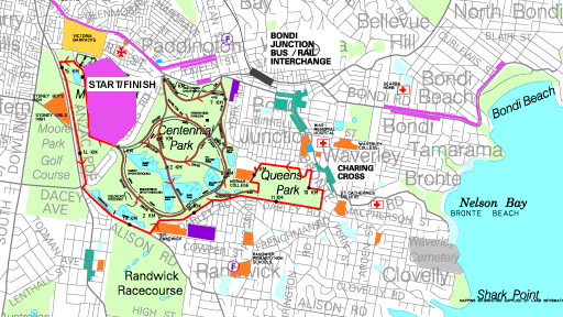
The time trial course is just a shortened version of the road course, cutting out the descent into Bronte by turning left at the top of Darley Rd into Carrington Rd. Then it is left into Victoria St, and Queens Park Rd as for the road race. The course is not overly technical, compared to the full course, but there are still enough turns in it.
Comments:
Susy Pryde (NZ): "It's a beautiful course, very good for spectators. I really like it. It will be a hard course because there aren't many opportunities to recover if you're suffering. There are enough technical bits in it to make it quite tricky, especially on the first few laps."
"The climbs are mostly power climbs - it's definitely not a real thin climbers course. But, they're hard enough to take the sap out of your legs after a few laps. Petra Rossner and Anna Wilson are my likely tips."
Geneviève Jeanson (Can) "[The time trial course] is more technical than the road race but it's a nice course. The corners I thought were easy were tough, and the corners I thought were more important were not so tough. The hardest one was entering into Centennial Park. The descent from Queen's park is quite fast but I think I found a good line through there."
Nathan O'Neill (Aus) "[The time trial course] is not too technical. There are enough open roads to wind it up for a bit."
Course Maps
Time Trial:
Road Course:
Course Profile:

•The Dunc Gray Velodrome •
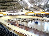 |
Track size: 250 metres.
Total length of track timber when laid end to end: 60 kilometres.
Number of nails used in construction: 360, 000.
Track racing surface: Baltic Pine [Finland.]
Surface angles: 42 degrees maximum [mid bends], 12 degree minimum [straights].
Track safety [duck board] width: 5 metres.
Track racing surface width: 7 metres.
Seating capacity: 3000 [6000 Olympic games]. The Velodrome has 3000 permanent spectator seats, ranked to provide the best possible viewing.
Track Information: The building contains athletes' change rooms and gymnasium, race and commentary facilities, venue and management rooms, spectator amenities and retail services. The metal decked roof contains glazed central skylights which have light control louvres. This enables natural lighting to be utilized and helps to eliminate shadows on the track. The louvres also enable warm air to be ventilated out of the velodrome and cooler air to be drawn in. Bicycle stands are situated at key entry points for spectators and competitors cycling to the venue. Access features include ramps, wheelchair seating, a lift, accessible amenities, accessible parking and tactile signage.
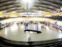 |
The 11,000 square metre fully enclosed velodrome is located on a 3.5 hectare site within the existing sporting complex at The Crest Park, Georges Hall, 3.5 kilometres from Bankstown Railway Station.
Transport: The site is approx. 2.5 km from Yagoona and Chester Hill stations. Buses leave these stations and travel to The Crest. There are approximately 1400 parking spaces available, but there will be no public parking during the Olympic Games. During this time visitors will be able to access the site via a shuttle bus service.
Dunc Gray: The Velodrome has been named after Dunc Gray, the first Australian cyclist to win a gold medal. The medal was won in 1932 in Los Angeles. Dunc Gray was an athlete who is passionately committed to the sport of cycling and was involved in the bid for the 2000 Sydney Olympics. He passed away in 1996 when he was 90 years old.
Mountain Bike Course - Fairfield City Farm
Course Description:
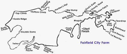
The course is 6.9 km long and passes through a variety of challenging terrains, providing the mountain bike competitors with an extremely rigorous ride.
Course designer, Glen Jacobs, planned the first half of the main course especially to give onlookers and the media a wonderful and exciting view of the action, as well as the beautiful views outlining the city. They are able to follow the competitors around sections such as the Dharuk Downhill and the Cauldron.
Cockatoo Gully to Double Dams is where the riders will reach their highest speeds as this is the biggest decent in the course. They are then introduced to a steep rise in the landscape and will reach the highest point in the course up at the Reservoir. Towards the end of the course they will have to climb one more back-breaking rise before they charge themselves up for the 50 metre dash down the straight towards the finish line. The mountain bike course has already been tested for the demands of Olympic competition during the 1999 Diesel/UCI Mountain Bike World Cup.
Farm Information: The Farm is open to the public seven days a week from 9am to 5pm (except for Christmas Day) .The farm is also closed during wet weather. The mountain bike track is open to be used by the public for running, walking,& riding on.
Schools have been utilizing the track for their cross country races and many other activities are available on the farm. Some of these include sheep shearing, whip cracking, milking, mustering, four-wheel drive tours, fishing, conferencing along with other farm activities for all ages. There is also a farmyard nursery.
How to get to the course:
Fairfield City Farm is a 186 hectare working farm located less than an hour's drive from the central business district of Sydney. Exit off the M4 Motorway at Wallgrove Road, take a left and then follow the Fairfield Farm signs which are brown. Parking is free.
Olympic Mountain Bike
Track Adventure Zone City Farm
31 Darling Street,
Abbotsbury NSW 2176
Tel: 02 9823
3222 Fax: 02 9823 4067 www.cityfarm.com.au
Course Map:
 |