
Time Trial Route and Map
|
Time Trial Route and Map |
|
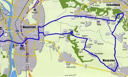
The Individual Time Trial starts in the heart of Maastricht - in a large
open space called the Vrijthof. This is an area where many activities are
organised during the year and is a central part of local life. The starting
ramp is to be in front of the Vrijthof Theatre, then turn rights along the
square into Papenstraat, which is bordered by the bars (terraces).
Turn right to head out of town along the winding Bouillonstraat, then sharp right into Tongersestraat and up a slight incline past the bars and cafes. My best mate says her favourite cafe is along here. No ads though!. The University of Maastricht is on the left (an old Jesuit Cloister). The riders come to the main roundabout - straight on to Tongeren, left to the Maas, right to the North Bridge and Hasselt. The riders sweep around the roundabout and left into Prins Bisschopsingel, a sweeping downhill and onto the Kennedybrug, the major south crossing point of the River Maas. On the right is the MECC where the infamous Maastricht Treaty was signed. Then the route follows the Akersteenweg, Vijverdalseweg, Doornlaan, Oude Molenweg, which take the riders out of the eastern suburbs of Maastricht and out towards the hills. They reach Bemelen and ride along the Oude Akerstraat which takes them to the Bemelerberg. As they head into the village of Bemelen, the road is starting to climb ever so slightly. They pass along the Oude Akerstraat before commencing the climb of the Bemelerberg (at 7.8 kms). The climb is not steep but it is long and their is a false flat at the top that goes on forever. As the riders come out of the wooded area that hides the winding climb up the Bemelerberg, they encounter farming fields which are on the top of the plateay. They pass along the Gasthuis, and instead of continuing on towards Valkenburg, which is the road race route, the time trial circuit turns right and heads to the village of Margraten via 't Rooth, Klein Welsden, Trichterweg, Hoenderstraat, Pastoor Brouwersstraat, Rijksweg Gulpen-Maastricht, Cadier en Keer Kerkstraat, Fommestraat, Honthem, Eckelrade, Dorpstraat, Molenweg, Sint Geertruid Burg. This part of the route takes the riders along narrow rural roads where there are some very sharp tough little hills. As the Netherlands merges into Belgium to the south, the riders turn back towards Valkenburg. The roads used are Wolfsstraat, Julianaweg, Langsteeg, Mheer Duivenstraat, Burg. Beckersweg, Banholt Mheerderweg, Dalestraat, Bergstraat, Bruisterbosch Bruisterboschweg, Margraten Broenshemweg, Termaar, Sterre der Zeestraat, Rijksweg, Sprinkstraat, Eijkerstraat, Eijkerweg, Sibbe Kenkersweg, and Bemelerweg. They are now back onto the Road Race circuit and after the Daalhemmerweg, they sweep down a very fast hill - Valkenburg Grendelplein - into the heart of Valkenburg. Here they turn sharp left and begin the tough 12 per cent climb of the Cauberg. With the finish only a few kilometres away the riders will be in their big rings up the Cauberg hoping to keep powering over the top. A foot bridge goes over the road towards the top of the Cauberg and I always use that as my guage of how much harder I can push when I am doing intervals. The path then is along the main road back into Maastricht - Rijksweg Valkenburg-Maastricht, with the finish in Vilt on the edge of Berg en Terblijt. The elite men do the complete 43.6 kilometre route. The women and junior men ride 23 kilometres and miss out on the southern part of the course around Mheer. The Under-23 men ride 32.8 kilometres and also miss the southern part of the course although they take a different path to the women and junior men. The junior women ride 15.2 kms and ride the route out to Bemelen, then up the Bemelerberg and once over the top continue on the road circuit but instead of going into Valkenburg and up the Cauberg, they turn left at the top and head straight down to the finish at Vilt. |
|