
Road Race Route and Map
|
Road Race Route and Map |
|
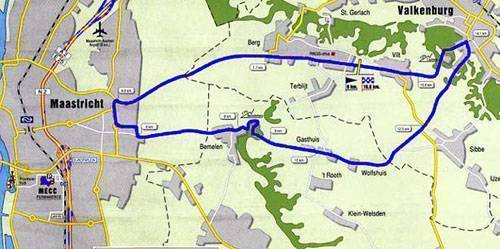
The road race circuit is 17.2 kilometres and the riders have to complete
15 laps of the parcours for a total distance of 258 kilometres. The highlight
will be the 12 per cent climb of the Cauberg, coming out of Valkenburg. The
finish after 15 laps is just over the top of the Cauberg.
The road race starts in Valkenburg on the main road (the Rijksweg) between Valkenburg and Maastricht just near the café Noben at 9.45 on Sunday, October 11. From there it travels in the direction of Maastricht via the Rasberg. It is a long downhill into the outer edges of Maastricht to the east. The roads used are the Terblijterweg, Vijverdalseweg, Doornlaan, and the Oude Molenweg. As they head into the village of Bemelen, the road is starting to climb ever so slightly. They pass along the Oude Akerstraat before commencing the climb of the Bemelerberg (at 7.8 kms). The climb is not steep but it is long and their is a false flat at the top that goes on forever. As the riders come out of the wooded area that hides the winding climb up the Bemelerberg, they encounter farming fields which are on the top of the plateay. They pass along the Gasthuis, Wolfshuis, Sibbe Bemelerweg, and Daalhemmerweg. Sometimes it is very windy up on the exposed top. By now the peloton is winging its way down the very fast road into Valkenburg and when they reach the Valkenburg Grendelplein it is a sharp left turn into the Cauberg. This area is full of tourist cafes and will be very crowded on the day of the race. Once over the top of the Cauberg the start-finish lines beckons. After 15 laps they finish on the Rijksweg Valkenburg-Maastricht, just near to the villages of Vilt and Berg en Terblijt. |
|